March 25, 2019
Drone usage is on the rise for urban and commercial real estate projects. Here's why you should take the FAA and its Part 107 for UAS seriously.
Drone usage is on the rise for urban and commercial real estate projects. Here's why you should take the FAA and its Part 107 for UAS seriously.
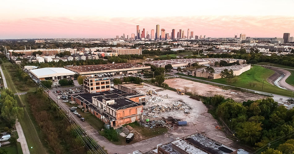
With the real estate industry’s evolution in recent years, any casual observer has seen drone photography and video in action. Think slow pans, aerial fly-bys, and new angles on urban projects that viewers are now able to consume like never before. Yet, with these fresh vantage points comes a new layer of responsibility, and the FAA calls it the Part 107 for small unmanned aircraft.
This article will cover what that is, why it matters, the steps to commercial licensure, and why this matters for every real estate and urban business.
A quick Google search will pull up countless articles and videos on the topic, some of which focus on a variety of urban industries (engineering, urban planning, and real estate).
The FAA Part 107 is not a particularly simple explanation, but what’s important to understand at a foundational level is that to operate an unmanned aircraft system (UAS) in a commercial setting, the remote pilot-in-command (PIC) must be certified by the FAA.
In a recent aerospace forecast put out by the FAA, specific mention is given about drone activity over our skies. The FAA now projects that the commercial, small non-model UAS fleet is set to grow from 110,604 in 2017 to 451,800 in 2022. The number of remote pilots is also set to increase from 73,673 in 2017 to 301,000 in 2022.
Within the commercial real estate industry or not, the numbers are clearly on the rise. Why is this important to note for your projects?
The FAA has needed a way to wrangle the hobbyist and commercial pilots into a system that clearly draws out rules and regulations of flying a quadcopter. After all, we’re sharing airspace with fixed wing aircraft and other hazards that are actually very serious.
A prevalent scenario in the urban or real estate industry is a drone pilot that either has not registered their aircraft, and/or has not completed the FAA Part 107 exam to become a licensed pilot. This lack of accountability—while at first blush can come across as “no big deal” to many—can actually have significant ramifications.
A baseline understanding of weather, unique obstacles, and general airspace rules (just to name a few topics) only scratch the surface of what’s tested on the FAA Part 107 exam.
Most drone pilots begin their journeys as hobbyists: learning the aircraft, having a little fun, and (hopefully) keeping things safe! But for many pilots, there comes a point when using a drone for commercial purposes becomes a very real factor.
Does that mean you need to become licensed? Does that mean you should be working with a licensed pilot for your real estate projects? The FAA says yes.
I’m in the camp with those that feel we do need regulation, and I’d say an exam is a great piece in that accountability puzzle. Without an understanding of basic flight rules and theory, a majority of drone pilots are truly “flying blind” without an understanding of the bigger picture. Myself included before digging into the study topics.
Real estate and urban businesses should keep an eye on this, too. Hiring a colleague’s teen son or daughter to capture drone assets might be something relied on in the past, but depending on project location and those bigger picture variables, it’s not the best decision.
Beyond the obvious issues of legality for commercial purposes, such a decision opens up liability on the part of the business and the pilot who may not understand preflight planning, preparation, and any other temporary flight restrictions in place around your location(s). Read on to learn more about these specific topic areas that the FAA expects a pilot to understand.
Remember, if your business chooses to work with an unlicensed pilot, you’re choosing to leave some accountability on the table.
“What does it take to get my own license?” You might be wondering what's involved to handle your own drone assets. Next, I'll explain what you can expect from the exam.
Becoming commercially licensed for drone operation in the U.S. is a surprisingly in-depth endeavor. Since the FAA is involved, perhaps it’s not that surprising, but when I first glanced at the material I was wide-eyed with all of the material that would be covered.
If you or a colleague is up for the task, start by setting expectations on the time it will take to prepare. For anyone with previous piloting experience, some of the topic areas may come easier, but in general plan on at least 10-16 hours of initial study time.
Are you interested in giving it a crack? A quick scan of the official FAA study guide paints a picture of what’s ahead: deep dive knowledge requirements including charts, weather reports, and more.
Keep in mind that this study guide at the time of writing this article was the only one available from the FAA. The problem? It’s going on 3 years old and many test questions I received aren’t covered in the study guide. Regardless, you’ll need to be comfortable with the concepts covered in the study guide in order to be successful on the test.
That’s a big tip: focus on really learning the concepts of what these study guides cover, because you cannot rely on memorizing sample test questions. The FAA really, really wants you to know various acronyms and systems or processes.
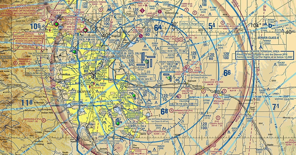
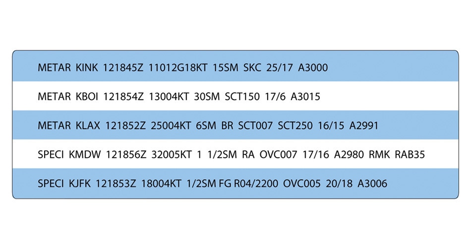
What are MOAs or NOTAMs and how do you use that information? How might high density altitude alter aircraft performance? Are you able to read a METAR report? How can you scan sectionals to determine if it's legal to fly over your urban project? The list goes on!
There are a few terrific videos online that served as a core component to my studying. Tony Northrup’s free study guide course gets all the basics right. Grab a drink and settle into almost two hours of the big picture being covered without even cracking the official study guide. Bonus points for Tony’s dry humor!
Beyond Tony’s video, there’s still a fair amount of information that needs to be covered. Keep in mind his video came out a few years ago now, and as I alluded to earlier, the FAA constantly updates exam questions and topic areas.
Another video that played a significant role in understanding the UAS concepts is found on Youtube, and it covers all 120 questions on a practice test prepared by 3DR.
Why not just jump to taking the test, you might be thinking? Because this video covers each question with reasons why. This one is another almost three hours of your time, but in my opinion it’s necessary.
Thankfully—but at the time alarmingly—I remembered I had the Prepware app on my phone the night before my scheduled test. I popped it open and started coming across questions and concepts I’d never seen before! Why? I realized the app was over a year newer than all other prep materials.
With that in mind, I ended up scrambling and finding a couple “newer” resources to cram with before my test (literally the morning-of). There were concepts in these study materials that I couldn’t find in the official FAA study guide itself.
I highly recommend you also study from the following links, too. In retrospect, the questions I did end up missing on my exam came from newer material that I hadn’t seen before in any other study materials to that point.
Once you’re ready to take the test, contact your closest FAA testing center and get it in the books! Once you’re at that point you’ll surely have come across more information about the actual exam, the cost, and what to expect when you walk in.

For any leader in the urban space—from architects and urban designers, to real estate developers and city groups—keep in mind that when you’re working with an unlicensed pilot you’re technically working with someone breaking FAA law. Simply put, that pilot or team won’t have an appropriate understanding of air rules.
Before you settle on a drone pilot for your projects, be sure to ask them about their certification and make sure they’re licensed. There is a physical license, too, so ask them for a copy for your records.
If all else fails, you can manually look pilots up in the FAA Airmen Registry yourself. The Part 107 certification is only valid for 24 months, so it’s possible they were once certified but are no longer.
Also, is their equipment registered with the FAA? Unsurprisingly, that’s required, too.
There is, of course, the aesthetic side to a pilot’s work that hasn’t been touched on in this article.
How does the pilot’s portfolio look? Are they confident in your scope and expectations? What, if any, limitations exist on your location(s) as far as airspace or other obstacles are concerned?
Create clear guidelines for you and your drone partner so that everyone is on the same page. Consider drafting a document or spreadsheet that covers the following key details:
With this information the first phase of a pilot’s work will be researching the locations within sectional charts to identify and potential airspace issues or physical hazards.
If the majority of your commercial real estate assets exist inside major class airspace, drone is likely out of the question unless you’re willing to have the pilot submit an exemption request at least 90 days out. Keep in mind this isn’t guaranteed, and, you can't control the weather in 90 days.
At a minimum, licensed pilots should be referencing both the Know Before You Fly Air U.S. Air Space Map as well as the DJI Fly Safe Geo Zone Map.
This information, cross-referenced with the local sectional chart, will inform your team on the potential hazards or legalities that may come into play for your shoot.
Clearly a lot goes into flying a drone for commercial purposes, and within the law that the FAA has now set standards for. What was once a hobbyist endeavor is now very much an in-depth and legitimate practice.
With the right partner(s) on your next urban project, your drone images and video footage will be better than ever—and within FAA regulations.
If you have questions about your next shoot, or simply want to reach out to ask us how we approach drone photography, don’t hesitate to contact me.
Subscribe here to get our short and sweet monthly newsletter!